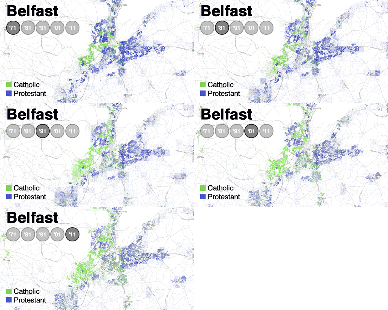
BELFAST is a city being transformed by the peace process, but also by demographics.
Population shifts across Northern Ireland have seen the decline of the two-thirds Protestant majority that was in place at the foundation of the state.
And trends in Belfast illustrate a similar swing towards the Catholic community emerging as the largest grouping.
The animated map above shows the scale of change in the city from 1971 to the modern era.
The patterns have had a political impact. Over recent elections Belfast city council lost its historic unionist majority to reach an effective balance between unionists and nationalists, with centrist parties in between.
That led to a vote in 2012 to end the tradition of flying the Union flag on city hall all year round, restricting it to designated days as happens on other government buildings.
The subsequent loyalist backlash attracted international media attention.
The map shows the expansion of the Catholic population in Belfast, though the last 40 years has also seen the growth of predominantly Protestant towns to the north and east of the city.
An analysis of demography in Belfast published by the Northern Ireland Assembly said: “The Catholic share of the population rose from 47% in 2001 to 49% in 2011, the Protestant fell from 49% to 42%, and those who declared no religion from 3% to 7%.”
It added: “Population within the Belfast council area has experienced a modest rise over the last decade, compared to a general pattern of decline from the 1970s onwards.”
The experience of Belfast City Council reflects the pattern shown in the recent election to the Northern Ireland Assembly, where the unionist bloc lost majority status.
DERRY-LONDONDERRY
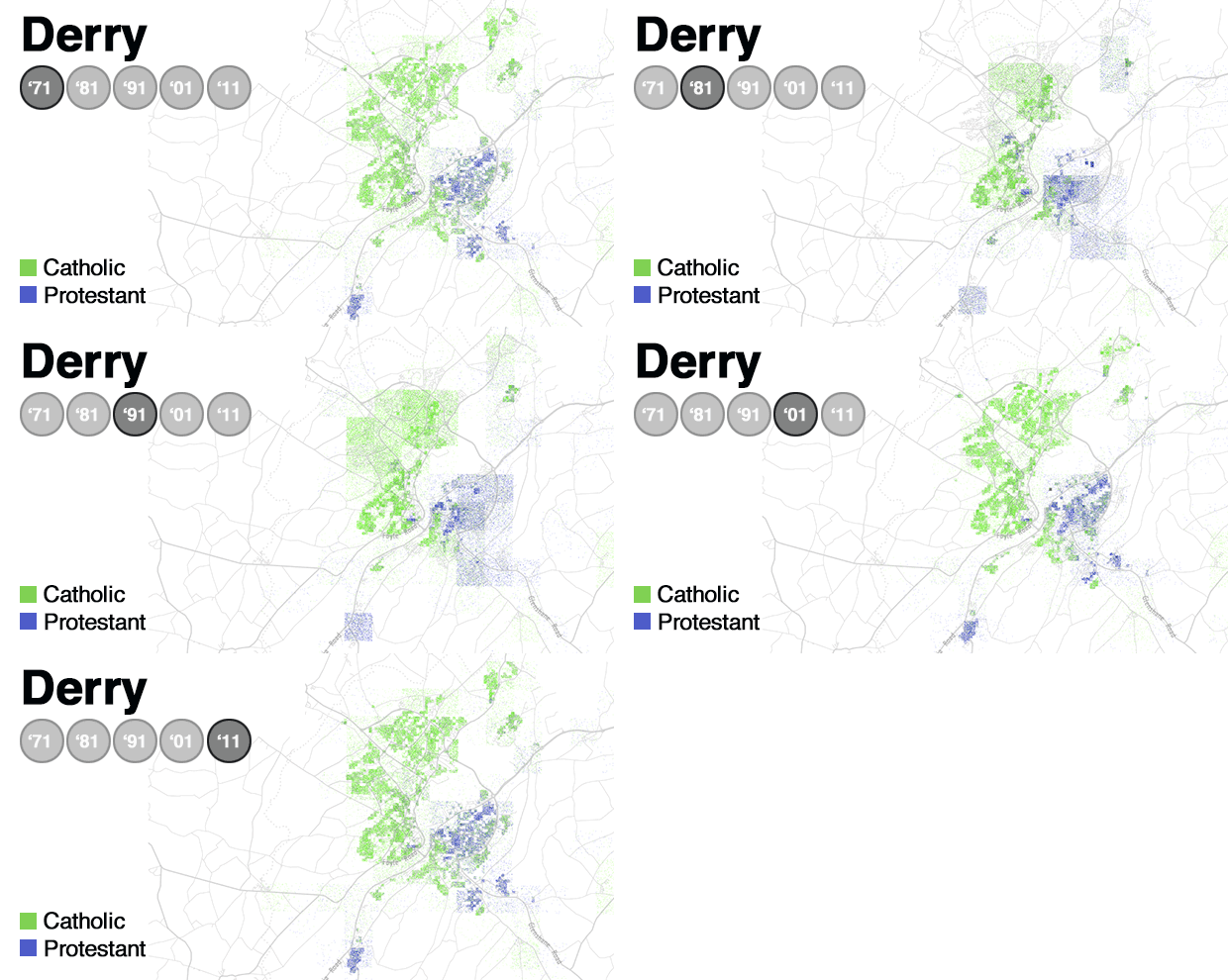
Derry-Londonderry is a city with two names and a place which the map shows has two distinct main communities.
The population changes in the map illustrate how the Protestant community was largely seen to have moved from the west to the east of the city, crossing the waters of the Foyle, during the decades of violence of the Troubles.
The 2011 census showed the Derry city area included 74.8% of people who belonged to or were brought up in the Catholic religion and 22.3% belonged to or were brought up in a 'Protestant and Other Christian' religion.
It found that 23.7% indicated that they had a British national identity, 55% had an Irish national identity and 24.6% had a Northern Irish national identity.
In 2013 the city made history in being chosen as the first ever UK City of Culture. It hosted a year-long celebration attracting international visitors.
In the same year it became the first northern venue to host the all-Ireland fleadh cheoil.
Despite its divisions Derry has forged important cross-community links and led the way in comparison with cities such as Belfast when it came to brokering deals on issues such as controversial parades.
- RETURN to main article here
- The Detail's map used census grid square data to plot a map with a dot for each person in Northern Ireland, colouring those dots by their religion as stated in each census included in the project. The dots are randomly placed within the appropriate 100m or 1km square, to maintain the demographic geography of each area whilst also anonymising the data and ensuring individuals cannot be identified or located. The data was provided by the Northern Ireland Statistics and Research Agency, but it is not involved in The Detail project. Republicans boycotted the 1981 census during the hunger strike at the Maze prison. Census worker Joanne Mathers was shot dead by the IRA as she collected forms in Derry. The animated versions of the map contained in this story were prepared by The Irish Times.
 By
By


